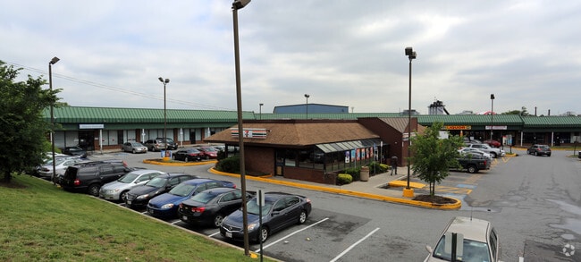
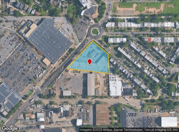
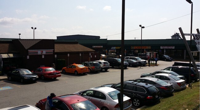
Property Record
1217 Brentwood Rd Ne, Washington, DC 20018

Current Lease Availabilities
NEARBY LISTINGS FOR SALE OR LEASE
Property Detail
1217 Brentwood Rd Ne
Washington-Arlington-Alexandria, DC-VA-MD-WV
Brentwood
3942-0040
SQUARE 3942 LOT 0040 NBHD: BRENTWOOD
Regionalshoppingcenterormallwithanchorstore
District of Columbia
X
District of Columbia
1100010036C
40
2025
1.96 AC
2025
Northeast
009102
Washington, DC
68,163 SF
DEMOGRAPHICS near 1217 Brentwood Rd Ne
1 Mile
3 Mile
5 Mile
2024 Total Population
31,694
356,010
747,354
2029 Population
29,678
327,180
695,592
Pop Growth 2024-2029
(6.36%)
(8.10%)
(6.93%)
Average Age
37
37
37
2024 Total Households
13,977
167,004
329,290
HH Growth 2024-2029
(6.69%)
(8.92%)
(7.91%)
Median Household Inc
$79,941
$98,234
$90,358
Avg Household Size
2.10
2.00
2.10
2024 Avg HH Vehicles
1.00
1.00
1.00
Median Home Value
$676,980
$691,781
$608,988
Median Year Built
1963
1955
1958
Nearby Places
Map Layers
Map Styles
 Street
 Aerial
- Restaurants
- Banks
- Shops
- Fitness
- Groceries
PUBLIC TRANSPORTATION
TRANSIT/SUBWAY
Rhode Island Ave-Brentwood (Red Line - Washington Metropolitan Area Transit Authority Metrorail (Metrorail))
DRIVE
WALK
Distance
Rhode Island Ave-Brentwood (Red Line - Washington Metropolitan Area Transit Authority Metrorail (Metrorail))
3 min
11 min
0.6 mi
COMMUTER RAIL
DRIVE
WALK
Distance
5 min
2.3 mi
Union Station (Red Line - Washington Metropolitan Area Transit Authority Metrorail (Metrorail))
DRIVE
WALK
Distance
Union Station (Red Line - Washington Metropolitan Area Transit Authority Metrorail (Metrorail))
7 min
2.5 mi
AIRPORT
Ronald Reagan Washington Ntl
DRIVE
WALK
Distance
Ronald Reagan Washington Ntl
15 min
8.2 mi
Baltimore/Washington International Thurgood Marshall
DRIVE
WALK
Distance
Baltimore/Washington International Thurgood Marshall
44 min
29.5 mi
Washington Dulles International
DRIVE
WALK
Distance
Washington Dulles International
50 min
30.9 mi
Freight Ports
Port of Baltimore
DRIVE
WALK
Distance
Port of Baltimore
53 min
35.8 mi
Nearby Properties
Address
Land Use
TOTAL SIZE
Lot Size
Zoning
Address
Land Use
TOTAL SIZE
Lot Size
Zoning
2,300,000 SF
1.60 AC
D-5-R
Address
Land Use
TOTAL SIZE
Lot Size
Zoning
2,052,109 SF
90.60 AC
UNZONED
Address
Land Use
TOTAL SIZE
Lot Size
Zoning
533,778 SF
18.08 AC
UNZONED
Address
Land Use
TOTAL SIZE
Lot Size
Zoning
5,483 SF
88.76 AC
GOV
Address
Land Use
TOTAL SIZE
Lot Size
Zoning
1,517,010 SF
70.25 AC
UNZONED
Address
Land Use
TOTAL SIZE
Lot Size
Zoning
142 AC
GOV
Address
Land Use
TOTAL SIZE
Lot Size
Zoning
2,493,936 SF
8.99 AC
UNZONED
Address
Land Use
TOTAL SIZE
Lot Size
Zoning
3.71 AC
UNZONED
Address
Land Use
TOTAL SIZE
Lot Size
Zoning
63.89 AC
GOV
Address
Land Use
TOTAL SIZE
Lot Size
Zoning
58,289 SF
418.97 AC
MU-4;PDR-1
Address
Land Use
TOTAL SIZE
Lot Size
Zoning
1,583,364 SF
276.66 AC
UNZONED
Address
Land Use
TOTAL SIZE
Lot Size
Zoning
262,673 SF
5.35 AC
D-7
Address
Land Use
TOTAL SIZE
Lot Size
Zoning
1,530,865 SF
6.05 AC
D-6;UNZONE
Address
Land Use
TOTAL SIZE
Lot Size
Zoning
42.57 AC
GOV
Address
Land Use
TOTAL SIZE
Lot Size
Zoning
1,100,000 SF
2.13 AC
D-6
Address
Land Use
TOTAL SIZE
Lot Size
Zoning
1,043,058 SF
4.03 AC
UNZONED
Address
Land Use
TOTAL SIZE
Lot Size
Zoning
1,738,573 SF
2.11 AC
D-7
Address
Land Use
TOTAL SIZE
Lot Size
Zoning
1,081,367 SF
6.46 AC
UNZONED
Address
Land Use
TOTAL SIZE
Lot Size
Zoning
185,826 SF
9.40 AC
UNZONED
Address
Land Use
TOTAL SIZE
Lot Size
Zoning
2,058,692 SF
4.77 AC
UNZONED
Address
Land Use
TOTAL SIZE
Lot Size
Zoning
1,015,833 SF
1.60 AC
D-7
Address
Land Use
TOTAL SIZE
Lot Size
Zoning
2,247,684 SF
6.39 AC
D-4-R
Address
Land Use
TOTAL SIZE
Lot Size
Zoning
607,735 SF
8.94 AC
PDR-3;UNZO
Address
Land Use
TOTAL SIZE
Lot Size
Zoning
758,000 SF
2.22 AC
D-4-R;MU-7
Address
Land Use
TOTAL SIZE
Lot Size
Zoning
4.95 AC
UNZONED
Address
Land Use
TOTAL SIZE
Lot Size
Zoning
1,562,988 SF
15.33 AC
MU-10 (IZ+
Address
Land Use
TOTAL SIZE
Lot Size
Zoning
2,542,436 SF
6.39 AC
MU-2;MU-4;
Address
Land Use
TOTAL SIZE
Lot Size
Zoning
479,505 SF
5 AC
D-6-R
Address
Land Use
TOTAL SIZE
Lot Size
Zoning
1,214,044 SF
1.48 AC
D-6
Address
Land Use
TOTAL SIZE
Lot Size
Zoning
1,375,218 SF
3.55 AC
D-4
The World's #1 Commercial Real Estate Marketplace
Connect with us
© 2025 CoStar Group
The information above has been obtained from sources believed reliable. While we do not doubt its accuracy we have not verified it and make no guarantee, warranty or representation about it. It is your responsibility to independently confirm its accuracy and completeness. Any projections, opinions, assumptions, or estimates used are for example only and do not represent the current or future performance of the property. The value of this transaction to you depends on tax and other factors which should be evaluated by your tax, financial, and legal advisors. You and your advisors should conduct a careful, independent investigation of the property to determine to your satisfaction the suitability of the property for your needs.